 Bookmark this on Delicious
 Recommend toStumbleUpon
(Editor's note to himselfff... there's stuff at the bottom of this page to be dealt with.)
This page is still being built at the moment... but I hope that already useful material is here.
This page is a sub-page off of my page about distinguishing editions of Cruchley's maps of London, itself a sub-page of my pages about Cruchley's maps. While this page may only interest a restricted audience, I hope that many people will find the main page interesting.
This page focuses on a detail of distinguishing one Cruchley from another, and is probably only of interest to collectors confronted with "what's this one??".
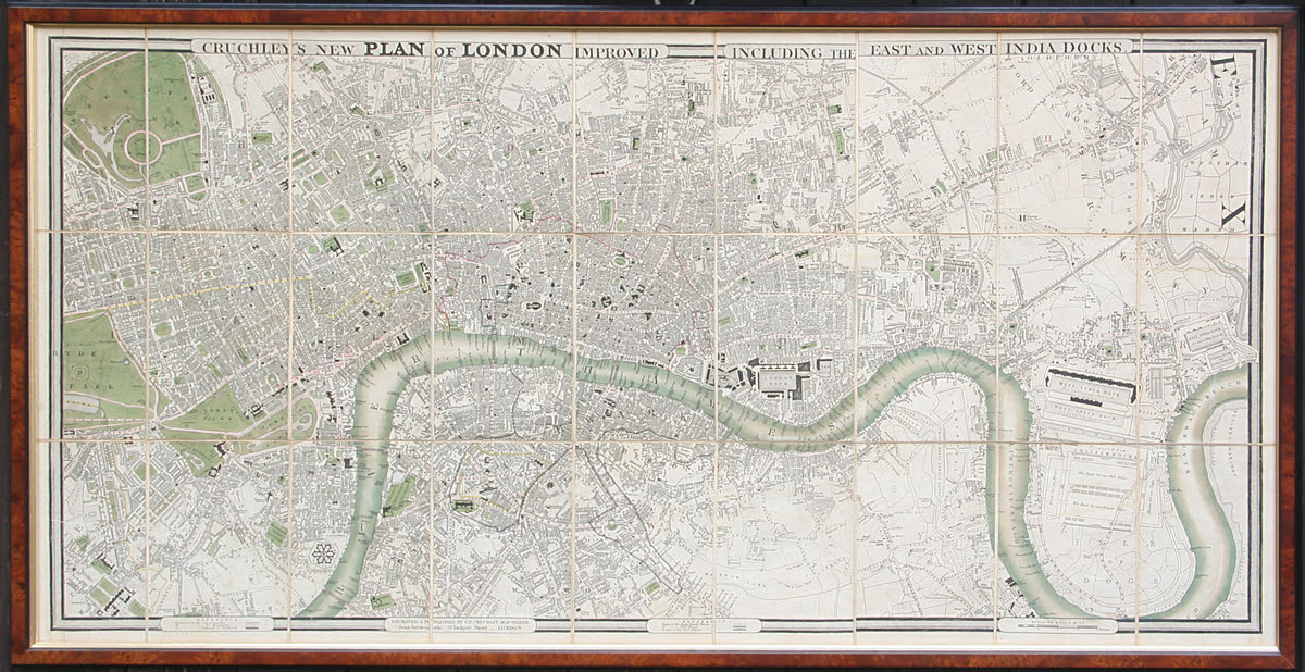
Have a look at the map in the image above. You can see, I hope, that it is made up of small panels... nine columns of panels, three to a column.
So- at a very basic level, we might call this a "9x3" map.
(I will give the number of elements across the page before I give the number of elements down the page, as is usual in many x/y coordinate nomenclatures. "Walk before you climb", as my geometry teacher used to tell me.)
In the map above, the long dimension of the panel is "vertical"... well, it will be if the image is on a typical monitor, so that the map looks like it is hanging on a wall. Sorry- that's just me being pedantic. We so often talk about something being at the "top" of a page, even though that page may be lying flat on a horizontal surface, making "top" dissociate from gravity. SORRY! Digression over. I promise.
That... the long edge of the panel being "vertical"... is, in my limited experience of Cruchleys, usual... but not unique. So, to our code, we will add a letter. The code for the above becomes "9Vx3", to indicate the orientation of the panels.
"9Hx3" would indicate a map with the panels rotated 90 degrees from what you see above. ("H" for "horizontal").
"9Sx3" would indicate a map with square panels.
In order to indicate where the "frame" has been placed by Cruchley, I am going to add to the code a further pair of numbers to indicate the location, on the overall map, of the panel in which St Paul's cathedral appears. I think you can just see it in the image above, though it may help to find St. Paul's on another map first. It is in the panel which is 4 from the left, and 2 down from the top. (Note where I am counting from, for the vertical dimension. And note that I am counting from 1 like a normal human, not from zero, which has advantages obvious to a computer oriented person. (I didn't say "geek", did I?)
So, now our code for the above is "9Vx3/4p2" (the "p" being there to remind us that the second pair locates St.Paul's)
("Leading" in the sense of "coming before", not "guiding")
Now... while a moment ago I resisted the charms of counting from zero, I will suggest that we "tweak" our code specification, changing the above map's code from...
9Vx3/4p2 ... to .. 09Vx3/4p2
In other words, if the number of panels across the whole map is less than ten, then we will agree to start the code with a zero. There are two reasons to do this: It will keep the format of the code consistent, and it will allow easy sorting of database records, if our catalogue of Cruchley editions gets as far as going into a database.
I think we are assuming that all of the other numbers in the code will only every require one digit. I hope so! (Well... all of the other numbers specified so far!)
What we have so far can be generated for any Cruchley, even from a relatively low resolution image.
I want to add two more pieces of information. They won't be available to the cataloger in every instance, but, coming at the right hand end of the specification, they won't interfere with what we can determine for any map. (They should be out in a second field, if the catalogue is put in a computer database.)
The two further data are the size of the panels, and the scale at which the map was drawn.
The panels in the map shown above are 10.9 cm x 16.2 cm. I would propose that this secondary code start with "11x16" for such a map. Be careful... sometimes the panels at the edge may be of a slightly different size, especially if you lean towards "not counting" any decorative border, etc.
I doubt that there will be significant variation in the sizes of the panels in any given map, but, just to be thorough, let's agree to use the "St. Paul's" panel, when specifying the panel dimensions.
As ever, the "horizontal" dimension should be given first.
For both the panel width and height, we will use leading zeros, if either dimension is less than 10cm.
While scale is traditionally expressed in phrases such as "Five inches to the mile", or "1:1200" (not that I am saying these are the same!), for our purposes, I propose we do something which may seem strange. Strange... but easy to implement. For those who want any of the traditional measures of scale, conversion tables are easily generated.
I propose that to indicate the scale of a given map, we indicate how many millimeters on the map represents one mile in the real world. As this is mathematical, I think we are allowed to mix our "metaphores".
Many of the Cruchley maps have a bar in one of the margins showing how long a mile (or half mile) is, and this is easily measured, if you have the map in front of you. And millimeters gives us a usefully discriminating measure, without being so precise that good readings become difficult.
The map above uses 122mm to represent one mile. (There's a note at the British Library site saying that this is a scale of 1:12600).
(I have read about one where he apparently used a slightly different scale, 3-3/4" to 1 mile. I think this was to make room for extensive text in the border areas.)
Following the two discussions above, "Panel Size" and "Scale", we are now ready to define a syntax for an abbreviated statement of any map's panel size and scale.
The map above, as I said, has 11 x 16 cm panels, uses 122mm for one mile. For that map, our panel size/scale code would be: "11x16s122".
Again: I would commend leading zeros. And the "s" is to help any reader know he/ she is looking at a panel size/ scale designator.
As an example of the "leading zero" issue, suppose you find a map with panels 7 cm x 9 cm, with a scale of 95mm per mile? It's panel size/ scale code would be "07x09s095". Simples!
From the above, I hope you can see that a map might be given a type designation of "09Vx3/4p2,11x16s122"
This will be most useful for people trying to check if a map they have is "known" in my list of specific versions of the map, as that has a "type designation", at least the first part, for each map I've examined. Others are forgiven if they won't be ready for any test on Friday.
Two things need to be kept in mind...
1) Suppose a map dealer had two Cruchley maps... a small one with a "good" left hand side (but damage to the right hand side), and a large one with a "good" right hand side. With a little careful work, he could produce a chimera, a map Cruchley never sold. Nice for the person who wants something nice to hang on the wall; not so nice for people trying to catalogue the editions of Cruchley's work! This may sound far-fetched, but I have seen an instance of the map with, if you look carefully, signs of surgery to do something about the border of the left edge of the map.
((TO BE WRITTEN UP... not forgetting to mention possibility of chimeras. Also of reuse, or even mixing, of panels. To diagram to show example.))
I said we'd start by grouping his maps by extent. I have (so far) seen maps consisting of...
If the panel size and orientation, and the scale the map is drawn at, don't change, then more panels means more land area represented on the map. And there appear to be instances of this simple formula applying.
Remember: This is just one of the sub-pages in a collection. Near the top of my main page about Cruchley's maps of London, there are links you can click to access other pages in the collection.
Search across all my sites with the Google search button at the top of the page the link will take you to.
Or...
Search just this site without using forms,
Or... again to search just this site, use...
The search engine merely looks for the words you type, so....
*! Spell them properly !*
Don't bother with "How do I get rich?" That will merely return pages with "how", "do", "I", "get" and "rich".
I have other sites. My Google custom search button will include things from them....
One of my SheepdogGuides pages.
My site at Arunet.
This page's editor, Tom Boyd, will be pleased if you get in touch by email.
![]() Page tested for compliance with INDUSTRY (not MS-only) standards, using the free, publicly accessible validator at validator.w3.org. Mostly passes. There were two "unknown attributes" in Google+ button code. Sigh.
Page tested for compliance with INDUSTRY (not MS-only) standards, using the free, publicly accessible validator at validator.w3.org. Mostly passes. There were two "unknown attributes" in Google+ button code. Sigh.